Guide to Brambrüesch Mountain Hiking Trails in Chur
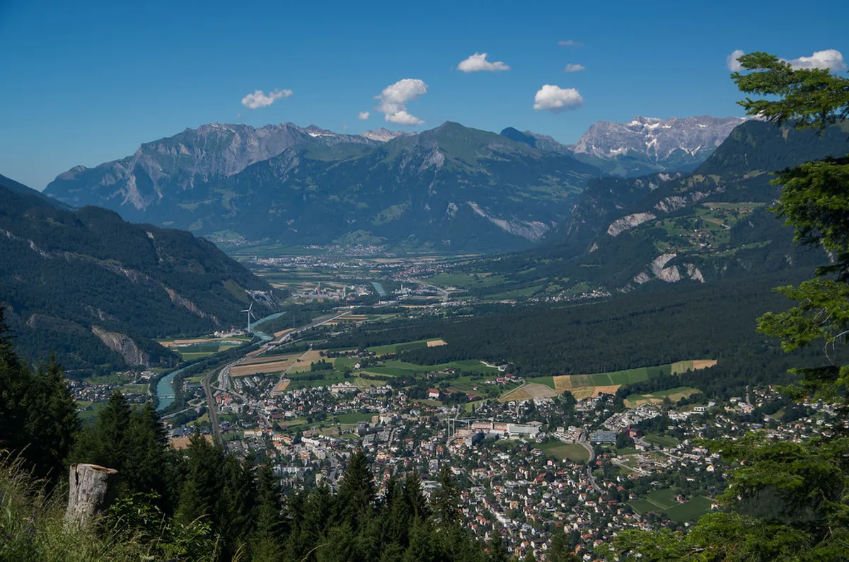
Chur serves as the perfect gateway to the stunning Brambrüesch mountain hiking trails. You can access high alpine plateaus directly from the historic city center. These paths offer breathtaking views of the Rhine Valley and the surrounding peaks. It is a must-visit destination for nature lovers traveling to Switzerland in 2026.
Getting to the Brambrüesch Mountain Hiking Trails
For current hours, prices, and announcements, start with Rhätische Bahn (RhB).
You can find the latest updates on Stadt Chur.
Reaching the summit starts with a scenic cable car ride from the heart of Chur. You will find the base station conveniently located near the old town district. The modern gondolas transport you from the valley floor to the mountain station quickly. This journey provides a unique transition from urban life to alpine wilderness.You should learn how to get to Brambrüesch cable car before your trip. The station is easily accessible by foot from the main Chur train station. Buses also stop frequently right outside the entrance for your convenience. Plan to arrive early to avoid the mid-morning crowds during peak summer months.
Ticket prices for the 2026 season remain competitive for international tourists. A standard round-trip ticket for adults costs approximately 32 Swiss Francs. Discounts are often available for holders of the Swiss Travel Pass or local guest cards. Check the official schedule for seasonal maintenance breaks before you head out.
Parking is available in the nearby multi-storey car parks if you are driving. However, using public transport is highly recommended to support local sustainability efforts. The cable car operates every twenty minutes during the busy hiking season. This frequency ensures you never have to wait long to start your adventure.
Top Brambrüesch Mountain Hiking Trails to Explore
The most famous route is the Brambrüesch to Pradaschier panoramic walking route. This trail follows a ridge that offers 360-degree views of the Grisons mountains. You will walk through lush meadows and past ancient stone formations. The path is well-maintained and clearly marked with yellow hiking signs.
Another excellent choice is the ascent to the Dreibündenstein summit. This historic point marks the former border of the three Rhaetian leagues. The hike takes about four hours to complete at a steady pace. You will reach an altitude of 2,160 meters above sea level here.
Many visitors enjoy the variety of scenic walks in Chur 2026 that connect to the mountain. You can choose to hike back down to the city for a challenge. This descent passes through dense pine forests and quiet mountain hamlets. It is a great way to see the changing landscape of the region.
Always carry a physical map or a reliable digital navigation app. While the trails are marked, mountain weather can change visibility very quickly. Look for the white-red-white painted stones that indicate mountain hiking paths. These markers help you stay on the correct track during your journey.
Brambrüesch Mountain Hiking Trails for Families
Families will find plenty of easy mountain walks for families in Chur. The Moorland Adventure Trail is a top highlight for children of all ages. This circular path features interactive stations that explain the local ecosystem. It is both educational and entertaining for young explorers.
The terrain on the upper plateau is relatively flat and easy to navigate. Many of these shorter loops are suitable for sturdy all-terrain strollers. You can enjoy a leisurely pace while the kids discover alpine flowers. The fresh mountain air provides a healthy environment for a family day out.
Several designated picnic areas are scattered along the family-friendly routes. These spots often include wooden benches and fire pits for public use. You can enjoy a traditional Swiss outdoor lunch with a view. Remember to pack out all your trash to keep the mountain clean.
- Moorland Adventure Trail (1.5 hours)
- Round trip to Malix (2 hours)
- Short loop to the Edelweiss bench (45 minutes)
- Playground path near the mountain station
Difficulty and Safety on Brambrüesch Trails
🌟 Local Expert Tip: Get the most out of your Chur visit with guided tours!
It is important to understand the Brambrüesch mountain trail difficulty for beginners. Most paths on the plateau are classified as easy or medium. However, the steeper sections require good footwear and basic hiking experience. Ensure your boots have deep treads for grip on loose gravel.
The Swiss hiking scale uses colors to indicate the level of challenge. Yellow signs mean easy walking paths with no special requirements. White-red-white signs indicate mountain trails that may be steep or narrow. Always choose a route that matches your current fitness level and experience.
Safety should be your primary concern when exploring the high Alps. Check the local weather forecast specifically for the mountain peak before leaving. Thunderstorms can develop rapidly in the afternoons during the summer season. Carry a lightweight rain jacket and an extra layer for warmth.
Tell someone at your hotel about your planned route and expected return. Mobile phone reception is generally good but can be spotty in deep valleys. Keep your phone battery charged and bring a portable power bank if possible. Emergency services can be reached by dialing 1414 in Switzerland.
Best Time to Visit Brambrüesch in 2026
Choosing the best time for Brambrüesch mountain walks 2026 is essential. The main hiking season typically runs from June through late October. During this window, the cable car operates daily and trails are snow-free. July and August offer the warmest temperatures for high-altitude trekking.
Autumn is a spectacular time to visit because of the vibrant colors. The larch trees turn a brilliant golden hue during the month of October. Visibility is often at its best during the crisp fall mornings. You can see distant peaks with incredible clarity on sunny autumn days.
Spring brings a carpet of wildflowers to the alpine meadows in May. However, some higher trails may still have patches of melting snow. You should check trail conditions with the local tourist office in Chur. They provide daily updates on which routes are safe for hiking.
Winter transforms the landscape into a snowy wonderland for different activities. You can enjoy groomed winter walking paths when the hiking trails are closed. These routes are specifically maintained for walkers without snowshoes or skis. It is a peaceful way to experience the mountain during the colder months.
Dining Options Along the Hiking Routes
Knowing where to eat on Brambrüesch hiking trails enhances your experience. Several traditional mountain huts offer hearty meals and refreshing drinks to hikers. You can taste local specialties like Capuns or authentic Swiss cheese fondue. Most restaurants feature large sun terraces with panoramic views of the Alps.
Berghaus Brambrüesch is a popular spot located right near the cable car station. It serves as an excellent starting or ending point for your day. The menu focuses on fresh ingredients sourced from local Grisons farmers. It is a cozy place to relax after a long morning of walking.
If you hike toward Pradaschier, you will find more dining options there. Many of these establishments offer outdoor seating during the summer of 2026. You can enjoy a cold beverage while watching mountain bikers on the trails. It is a lively atmosphere that captures the spirit of Swiss mountain life.
Reservations are recommended for larger groups or during busy weekend lunch hours. Most huts accept credit cards, but carrying some cash is always a good idea. Hydration is key, so remember to refill your water bottles at the stations. Many restaurants provide free mountain water for their guests.
Frequently Asked Questions
How long does it take to hike the Brambrüesch mountain hiking trails?
The duration depends on the specific route you choose to explore. Most popular loops take between two and four hours to complete. The panoramic hike to Pradaschier usually requires about three hours of walking time. Always allow extra time for photos and rest stops.
Are the hiking trails in Chur suitable for beginners?
Yes, many trails on the plateau are perfect for those new to hiking. These paths are relatively flat and very well-marked for easy navigation. Beginners should start with the Moorland Adventure Trail or the shorter circular loops. Proper footwear is still recommended for safety.
Can I bring my dog on the cable car and hiking trails?
Dogs are welcome on the cable car and all the mountain trails. You may need to purchase a small ticket for your pet on the gondola. Ensure your dog is on a lead when passing through grazing areas. Always clean up after your pet to protect the environment.
What should I pack for a day of hiking on Brambrüesch?
Pack plenty of water, high-energy snacks, and a basic first-aid kit. Wear layers of clothing to adjust to changing mountain temperatures. A sun hat and high-SPF sunscreen are vital at high altitudes. Don't forget a waterproof jacket even if the sky looks clear.
The Brambrüesch mountain hiking trails offer an unforgettable Swiss experience for every visitor. From panoramic ridges to family adventures, Chur provides world-class access to the Alps. Plan your visit in 2026 to enjoy these well-maintained paths and stunning vistas. Start your journey today by booking your stay in the historic city of Chur.