Best Lake Thun Walking Path Maps for Tourists in 2026
Lake Thun offers some of the most beautiful views in Switzerland. You can explore these trails easily from Interlaken. Use Lake Thun walking path maps for tourists to find your way. These maps highlight the best views and rest stops for 2026.
Accessing Lake Thun Walking Path Maps for Tourists
You can find maps at the Interlaken West train station. Local tourist offices provide free paper maps for visitors. Digital maps are also available through official Swiss hiking apps. These tools ensure you stay on the right path during your journey.
Paper maps are very reliable when phone batteries run low. They show detailed contour lines and local landmarks clearly. You can also find large map boards at most trailheads. These boards help you plan your next turn while walking.
Official Lake Thun scenic paths are marked with yellow signs. These signs indicate the direction and estimated walking time. Most tourists find these markers very easy to follow. They make navigating the lakeshore simple and stress-free.
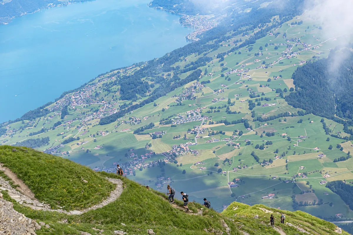
Top Lake Thun Scenic Paths Near Interlaken
The northern shore features many flat and easy walking trails. You will see turquoise water and majestic mountains at every turn. Many paths connect small villages like Unterseen and Merligen. These routes are perfect for families visiting Interlaken in 2026.
One popular route follows the shoreline toward the St. Beatus Caves. This path offers shaded sections and several picnic spots. You can enjoy a lunch break with a view of the Alps. The walk from Interlaken takes about two hours one way.
The southern shore offers more elevation and forest trails. These paths provide a different perspective of the surrounding landscape. You will find fewer crowds on this side of the lake. Use your maps to find the hidden viewpoints above Spiez.
Many trails are suitable for dogs and young children. The paths are well-maintained and clearly marked with yellow signs. You will find benches located at regular intervals for resting. These scenic walks in Interlaken 2026 are truly world-class.
Walking from Interlaken West to Neuhaus Beach
The walk to Neuhaus Beach is a local favorite. It starts right behind the Interlaken West train station. The path follows the Aare River toward the lake entrance. This flat route is ideal for a relaxing afternoon stroll.
You will pass through the beautiful Neuhaus nature reserve. This area is home to many bird species and native plants. Please stay on the marked trails to protect the local environment. The walk takes approximately 45 minutes to complete.
Neuhaus Beach offers a great place to swim in summer. There is a small cafe where you can buy snacks. You can also rent paddleboards or kayaks at the beach. It is a perfect spot to watch the sunset over the water.
To return, you can take a local bus back to town. The bus stop is located near the main entrance of the beach. Your walking from Interlaken West to Neuhaus Beach experience will be memorable. Buses run every 30 minutes during the peak season.
Navigating the Panorama Bridge at Sigriswil
🌟 Local Expert Tip: Get the most out of your Interlaken visit with guided tours!
The Panorama Bridge at Sigriswil is a highlight of the region. This bridge hangs 182 meters above the ground for amazing views. You can reach this spot by taking a bus from Thun. It connects the villages of Sigriswil and Aeschlen across a deep gorge.
Walking across the bridge requires a small fee for maintenance. In 2026, the price for adults is approximately 8 Swiss Francs. Children often get a discount when accompanied by an adult. The ticket office provides local maps for the surrounding trails.
The path from the bridge leads toward the lake shore. You will pass through lush green meadows and traditional Swiss farms. The descent takes about one hour to reach the water. Follow the yellow hiking signs to stay on the correct route.
Many hikers choose to combine this walk with a boat ride. You can walk down to the Gunten boat pier easily. Boats run frequently between Gunten and Interlaken during the summer months. This combination allows you to see the lake from two perspectives.
Essential Tips for Lake Thun Walking in 2026
💡 Pro Tip: Book your Interlaken adventures in advance through Viator for the best deals!
Check the weather forecast before you start your walk. Mountain weather can change quickly even in the summer months. Carry a light rain jacket in your day pack. Always tell someone your planned route before heading out.
The Swiss sun can be very strong near the water. Wear sunscreen and a hat to protect your skin. Drink plenty of water throughout your journey around the lake. Public fountains offer clean and cold drinking water for free.
Respect the local wildlife and private property along the paths. Keep your dog on a leash in protected nature areas. Dispose of your trash in the bins provided at rest stops. This helps keep Lake Thun beautiful for everyone to enjoy.
Frequently Asked Questions
Where can I get Lake Thun walking path maps for tourists?
You can pick up free paper maps at the Interlaken West tourist office. Digital versions are available on the official Interlaken tourism website. Many hotels also provide local trail maps to their guests. These resources help you find lake Thun boat and walk combined itineraries easily.
Are the walking paths around Lake Thun difficult?
Most shoreline paths are flat and very easy for beginners. They are suitable for families with strollers and senior travelers. Higher trails on the hillsides offer more of a challenge. Always check the difficulty rating on your map before starting.
Is there a fee to use the Lake Thun walking paths?
Most walking paths around Lake Thun are completely free to use. Only specific attractions like the Sigriswil Panorama Bridge require a small fee. You can enjoy hours of scenic walking without spending any money. This makes it a great activity for budget travelers.
Lake Thun provides endless beauty for every visitor in 2026. Use your maps to find the best trails today. Explore the shores and enjoy the fresh mountain air. Your Swiss adventure starts with a single step along these paths.