Guide to Brambrüesch Winter Hiking Trails Map
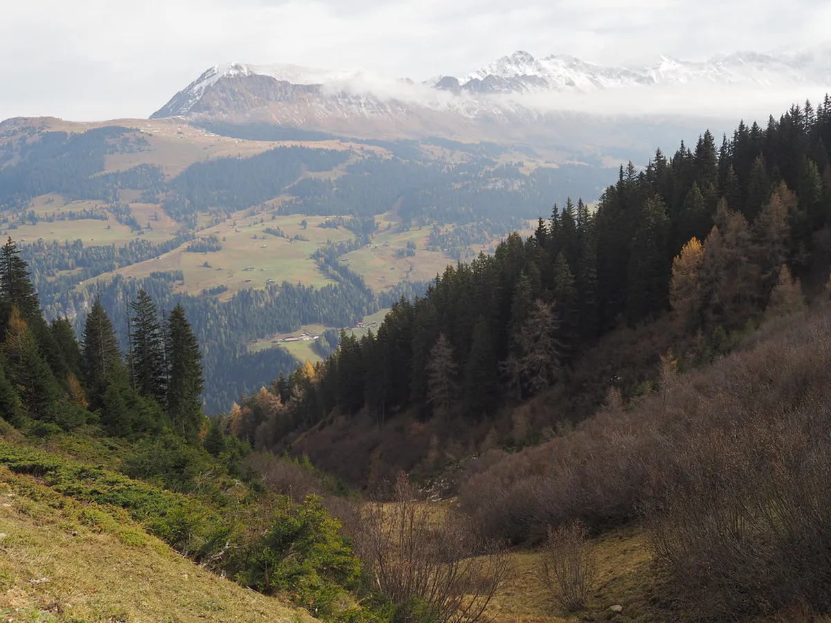
Brambrüesch serves as the stunning local mountain for the historic city of Chur. This high-altitude plateau offers a magical escape for winter lovers. Our Brambrüesch winter hiking trails map and guide will help you navigate this snowy paradise easily. You can enjoy panoramic views of the Rhine Valley while walking through quiet forests.
Finding the right path is simple with the well-marked winter walking trails in Chur. The mountain air is crisp and the scenery is truly breathtaking. This guide covers everything from trail maps to cozy mountain huts. Prepare for an unforgettable alpine experience in the heart of Graubünden.
Navigating the Brambrüesch Winter Hiking Map
For practical details and last-minute changes, use Chur travel info.
The Brambrüesch winter hiking trails map and guide is your best friend on the mountain. You can pick up a physical copy at the cable car station in Chur. The map clearly shows several kilometers of prepared paths for 2026. These trails are groomed regularly to ensure a safe walking surface.Trails are color-coded based on their difficulty and steepness. Blue paths are generally flat and perfect for families or casual strollers. Pink markers indicate official winter hiking routes that are cleared of deep snow. Always follow these markers to stay on the safe, designated paths.
The map also highlights important facilities like restrooms and emergency points. You will find clear signage at every major trail junction on the mountain. Digital versions are also available via QR codes at the valley station. This makes it easy to track your progress using your smartphone.
Most trails start right next to the mountain cable car exit. This area is known as the Bergbaiz hub. From here, you can choose routes that head toward Pradaschier or Feldis. The map provides estimated walking times for each direction to help you plan.
Top Winter Walking Trails in Chur's Highlands
The most famous route is the high-level hike from Brambrüesch to Pradaschier. This trail offers incredible views of the surrounding peaks and deep valleys. It covers about six kilometers and takes roughly two hours to complete. The path is mostly level with only gentle climbs and descents.
Another excellent option is the Edelweiss circular trail. This shorter loop is perfect for those with limited time in 2026. It takes about forty-five minutes and stays close to the main mountain village. You will pass through charming alpine meadows covered in thick white snow.
For a more challenging adventure, consider the Brambrüesch mountain hiking trails that lead toward the Dreibündenstein. This spot marks the intersection of three former local districts. The climb is steeper but the 360-degree view is worth the extra effort. Ensure you have good stamina for this specific route.
Always check the trail status board before you start your walk. Some paths may close temporarily after heavy snowfall for grooming. The morning sun provides the best light for photography on these trails. Early birds often see local wildlife like chamois near the forest edges.
Essential Gear and Safety for Winter Hiking
Proper preparation is key for a successful day on the mountain. Sturdy, waterproof hiking boots are the most important piece of gear. The snow can be slippery even on well-groomed paths. Consider using ice cleats or spikes for extra grip on frozen sections.
Dressing in layers helps you manage your body temperature effectively. Start with a moisture-wicking base layer to stay dry. Add a fleece or down jacket for warmth and a waterproof shell. You can find more details on what to wear for Chur winter walks to stay comfortable.
Safety should always be your top priority when visiting the Swiss Alps. Always tell someone your planned route and expected return time. Carry a fully charged phone and a portable power bank. Cold temperatures can drain your phone battery much faster than usual.
Review the safety tips for winter walking in Chur before heading out. Stay on the marked trails to avoid hidden holes or thin ice. Sunscreen is also vital because the snow reflects intense UV rays. Even on cloudy days, the alpine sun can cause unexpected burns.
Practical Tips for Your Brambrüesch Visit
💡 Pro Tip: Book your Chur adventures in advance through Viator for the best deals!
The Chur-Brambrüesch cable car operates daily from 8:20 AM to 4:00 PM. A return ticket for adults costs approximately 28 CHF in 2026. You can buy tickets online to skip the morning queues. The valley station is just a short walk from the main train station.
Hungry hikers have several great dining options on the mountain. The Battagliahütte is famous for its traditional Swiss barley soup and nut cake. Most restaurants offer outdoor seating with warm blankets for sunny winter days. It is a perfect spot to rest your legs and enjoy the view.
Weekends can be quite busy with local skiers and families. If possible, plan your hike for a weekday for a quieter experience. The trails feel much more peaceful when you have them to yourself. You will also find it easier to get a table at the huts.
Check the local weather forecast specifically for the mountain peak. Conditions at 2,000 meters can differ greatly from the city below. High winds can sometimes cause the cable car to stop running. Always verify the operational status on the official website before you leave.
Frequently Asked Questions
🌟 Local Expert Tip: Get the most out of your Chur visit with guided tours!
Where can I find a Brambrüesch winter hiking trails map and guide?
You can obtain a physical map at the Chur cable car valley station. Digital versions are available on the official Chur tourism website. These maps show all groomed trails, difficulty levels, and mountain restaurants for the 2026 season.
How long does the hike from Brambrüesch to Pradaschier take?
The popular trail from Brambrüesch to Pradaschier typically takes about two hours. It covers a distance of 6 kilometers on mostly flat terrain. This route is well-prepared and suitable for hikers with average fitness levels.
Is winter hiking on Brambrüesch suitable for beginners?
Yes, Brambrüesch offers several easy trails perfect for beginners. The Edelweiss circular loop is particularly gentle and well-marked. Most paths are groomed daily to provide a stable walking surface for everyone.
Brambrüesch is a premier destination for winter hiking in Switzerland. Using a Brambrüesch winter hiking trails map and guide ensures a smooth trip. You will enjoy fresh air, stunning views, and cozy mountain hospitality. Plan your visit today and experience the beauty of Chur from above.