Top Gornergrat Hiking Routes and Walks in Zermatt 2026
Zermatt is a dream destination for mountain lovers. The Gornergrat area offers some of the best views in Switzerland. Exploring Gornergrat hiking routes and walks allows you to see the Matterhorn up close. This guide will help you choose the best trails for your trip in 2026.
Scenic Gornergrat Hiking Routes and Walks
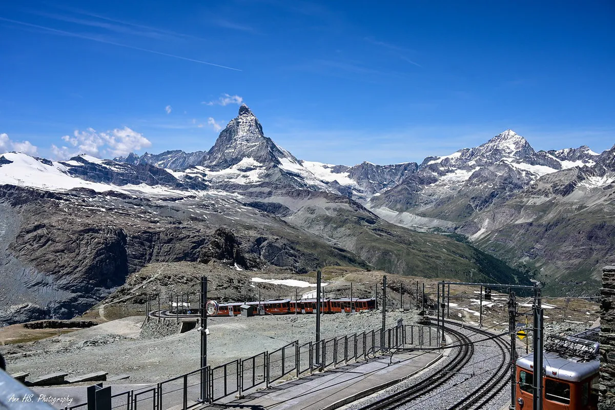
The Gornergrat summit sits at 3,089 meters above sea level. This peak offers the best views of the Gorner Glacier. You can see twenty-nine peaks over 4,000 meters high from here. Exploring Gornergrat hiking routes and walks starts with this incredible panorama.
The Gornergrat Railway is the easiest way to reach the top. It is the highest open-air rack railway in Europe. You should check the Gornergrat railway stops for scenic alpine walks before you go. This helps you plan where to start your hike.
Most hikers choose to walk down from the summit station. The path to Rotenboden is wide and well-marked for tourists. You will walk over rocky terrain with constant mountain views. Keep your camera ready for the stunning glacier ice below.
The air is thin at this high altitude in Zermatt. Take slow steps and drink plenty of water as you walk. You might see alpine choughs flying near the summit restaurant. These black birds love to watch hikers from the rocky ledges.
The Iconic Riffelsee Lake Path
The trail from Rotenboden to Riffelberg is very popular. It features the famous Riffelsee lake along the way. This small alpine lake is a highlight of many Zermatt lake trails in 2026. You can see the Matterhorn reflected in the still water.
Plan your visit for early morning to get the best photos. The wind is usually calm during the first hours of daylight. This creates a perfect mirror effect on the lake surface. Many photographers wait here for hours to catch the perfect light.
The walk between these two stations takes about one hour. It is mostly downhill and suitable for most fitness levels. You will pass through beautiful alpine meadows filled with wildflowers. Look for the rare edelweiss growing near the rocky path edges.
Riffelberg station offers a great place to rest and eat. There are several mountain restaurants with large outdoor sun terraces. You can enjoy traditional Swiss cheese fondue while watching the trains pass. This stop is a favorite for families with young children.
Gornergrat Hiking Routes and Walks Difficulty
Walking all the way back to Zermatt is a big challenge. This route covers a massive 1,500-meter drop in elevation. It usually takes five to six hours to complete the full journey. You will need strong legs for this long mountain descent.
The trail changes from rocky peaks to lush green forests. You will follow the trail from Gornergrat to Riffelberg first. After Riffelberg, the path enters the pine trees near Riffelalp. The scent of fresh wood fills the air in this section.
Your knees will feel the pressure of the steep descent. Using trekking poles is highly recommended for this long journey. The path can be slippery if it rained the night before. Wear sturdy boots with good grip to stay safe on the rocks.
There are many places to stop for water along the way. Local mountain huts provide cold drinks and snacks for tired hikers. You will pass through the charming hamlet of Findeln near the end. This area is famous for its high-quality gourmet mountain restaurants.
The final stretch leads you back into the car-free village. You will walk past traditional wooden barns and narrow stone streets. Reaching the village center feels like a great physical achievement. Reward yourself with a cold drink at a local cafe.
Planning Your Gornergrat Hiking Trip
🌟 Local Expert Tip: Get the most out of your Zermatt visit with guided tours!
Preparation is the key to a successful day on the mountain. You must pack the right Zermatt hiking gear essentials for 2026. Weather in the Swiss Alps can change in just a few minutes. Always carry a waterproof jacket even on sunny days.
Sun protection is vital at high altitudes near the glaciers. The sun is much stronger at 3,000 meters than in the valley. Wear a hat and apply high-factor sunscreen every few hours. Polarized sunglasses will help protect your eyes from the bright snow glare.
- Waterproof and windproof outer jacket
- High-factor sunscreen and lip balm
- Polarized sunglasses for snow glare
- Sturdy hiking boots with ankle support
- Physical trail map and fully charged phone
Check the local weather forecast before you leave your hotel. Mountain storms can be dangerous if you are caught on an open ridge. The Gornergrat Railway staff can provide updates on trail conditions. Follow all safety signs and stay on the marked hiking paths.
Carry a physical map of the Zermatt hiking area with you. Phone batteries can drain quickly in the cold mountain air. A paper map is a reliable backup for navigating the many trails. You can find free maps at the Zermatt tourism office.
Best Seasons for Gornergrat Walks
The best time for Gornergrat hiking routes and walks is from June to October. Snow often covers the high trails until the start of summer. In 2026, the official hiking season will begin in mid-June. Most mountain restaurants and train stations are fully open during this time.
July and August offer the warmest weather for alpine walks. Daytime temperatures at the summit range from 5°C to 12°C. The valley floor in Zermatt will be much warmer at 20°C. Layer your clothing so you can adjust to these temperature changes.
September is a wonderful month for quiet trails and clear skies. The autumn colors begin to appear in the larch forests below. You will find fewer crowds at the popular Riffelsee photo spots. The air is often very crisp and provides excellent visibility.
Winter offers a different experience for those who love the snow. Some lower paths are groomed for winter walking between the train stops. Always check which winter trails are open before you start walking. The snowy scenery makes the Matterhorn look even more impressive.
Frequently Asked Questions
🌟 Local Expert Tip: Get the most out of your Zermatt visit with guided tours!
How difficult are the hiking trails from Gornergrat?
The difficulty varies depending on the specific path you choose. You should understand the Gornergrat to Zermatt hike difficulty before starting. Most upper trails are moderate, but the long descent to the village requires good fitness and steady knees.
How do I buy tickets for the mountain railway?
You can learn how to buy Gornergrat hiking train tickets online or at the station. Prices for a return trip usually cost around 110 CHF in 2026. Buying in advance saves time during the busy summer morning rush.
What should I do if I feel dizzy at the summit?
Dizziness can be a sign of altitude sickness at 3,000 meters. Read some high altitude walking tips to stay safe. If you feel unwell, sit down, drink water, and take the next train to a lower elevation.
Can I see the Matterhorn reflection every day?
The reflection in Riffelsee depends on the weather and wind. You need a clear sky and very calm water for the best effect. Early morning is the best time to visit for a perfect reflection on the lake.
Are the trails at Gornergrat safe for children?
Yes, the path from Rotenboden to Riffelberg is very safe for families. It is wide and does not have dangerous drops. Always keep children close and ensure they wear proper shoes for the rocky sections.
Exploring Gornergrat hiking routes and walks is an unforgettable Swiss experience. You will see glaciers, lakes, and the mighty Matterhorn. Remember to pack your gear and check the weather for 2026. Start your adventure today by booking your train tickets to the summit!