Discover the Best Mt Pilatus Walking Paths in 2026
Mount Pilatus offers some of the most stunning scenery in the Swiss Alps. These legendary peaks tower directly over the historic city of Lucerne. Exploring the Mt Pilatus walking paths is a must for any visitor in 2026. You will find trails that suit every fitness level and age group.
The mountain features rugged cliffs and lush alpine meadows. Hikers can enjoy panoramic views of Lake Lucerne and the surrounding peaks. Many paths are easily accessible via the world's steepest cogwheel railway. You can also reach the summit using a modern aerial cableway. This guide will help you choose the perfect scenic walks in Lucerne for your trip.
How to Reach Mt Pilatus Walking Paths
Getting to the start of the trails is an adventure itself. Most visitors choose the famous Golden Round Trip from Lucerne. This journey includes a boat ride, a cogwheel train, and a cable car. It provides a complete experience of the mountain's diverse landscapes. You should check the Lucerne transport for walkers before you depart.
The cogwheel railway departs from Alpnachstad and climbs steep rock faces. It operates from May through November depending on the snow. A return ticket for adults costs approximately 72 CHF in 2026. Swiss Travel Pass holders receive a 50 percent discount on this fare. The ride takes about 30 minutes to reach the top station.
Alternatively, you can take the panoramic gondola from Kriens. This route stays open year-round for hikers and snow sports fans. The cable car stops at Krienseregg and Fräkmüntegg stations. These middle stations serve as great starting points for lower-altitude walks. You can buy tickets at the valley station or online.
Always check the live webcam before you leave the city. Mountain weather changes quickly even on sunny days in Lucerne. The summit stands at 2,132 meters above sea level. This height means temperatures are much cooler than in the valley. Bring an extra layer of clothing for your mountain journey.
Easy Mt Pilatus Walking Paths for Families
Families will find several gentle trails near the Pilatus Kulm station. The Dragon Path is the most popular choice for small children. This short loop takes about 15 minutes to complete. It features galleries carved into the rock with windows facing the peaks. You will learn about the dragons that supposedly lived here.
The Dragon path walk on Mt Pilatus is paved and very safe. It offers incredible views without requiring much physical effort. Benches are available along the route for resting and taking photos. This path is suitable for anyone wearing standard walking shoes. It remains open even during light rain or fog.
Another excellent option is the Mt Pilatus flower trail walking guide 2026 for nature lovers. This path showcases over 100 species of alpine plants and flowers. Information boards explain the unique flora found at this high altitude. The best time to see the blooms is from June to August. It is a relaxing way to enjoy the mountain air.
The Flower Trail is mostly flat and easy to navigate. It circles the Oberhaupt peak and provides 360-degree views. You can see as far as the Black Forest on clear days. This trail is perfect for photographers who want close-up shots of wildflowers. It takes roughly 30 minutes at a leisurely pace.
The Best Views from Mt Pilatus Walking Trails
If you want the ultimate vista, head toward the Tomlishorn. This is the highest peak in the Pilatus mountain massif. The path starts at the Pilatus Kulm hotel and follows a ridge. It is well-maintained but features some steep drops on the sides. Safety railings protect walkers along the most exposed sections.
The walking from Mt Pilatus Kulm to Tomlishorn takes 30 minutes. You will reach an elevation of 2,128 meters at the summit. The view from the top is truly breathtaking and unforgettable. You can see the Eiger, Mönch, and Jungfrau peaks in the distance. This route is a highlight for many Swiss travelers.
For a shorter climb, try the stairs up to the Esel peak. This viewpoint sits directly above the mountain railway station. It takes only 10 minutes to reach the top platform. The stairs are steep but the reward is a bird's-eye view. You can watch the cogwheel trains climbing the mountain below you.
The Oberhaupt peak offers another fantastic perspective of the region. It is located on the opposite side of the summit complex. This path is less crowded than the Esel stairs. It provides a quiet spot to watch the sunset over Lucerne. Many visitors consider this one of the best photo spots.
Planning Your Hike on Mt Pilatus in 2026
💡 Pro Tip: Book your Lucerne adventures in advance through Viator for the best deals!
Success on the mountain requires proper planning and the right gear. Even easy trails require shoes with good grip and support. Alpine weather can bring sudden wind or temperature drops. You should always carry a light waterproof jacket in your pack. Sunscreen is essential because the UV rays are strong at high altitudes.
You might wonder how difficult are Mt Pilatus walking paths for beginners. Most trails near the summit are rated as easy to moderate. However, paths leading down the mountain require more stamina and focus. Steep sections can be hard on your knees and ankles. Take your time and use trekking poles if you have them.
The official hiking season runs from late May to October. Some high-altitude paths may stay closed due to snow in early June. Always check the trail status board at the valley stations. Staff can provide advice on which routes are currently safe. Never ignore closed trail signs or venture off the marked paths.
Hydration is very important when walking in the thin mountain air. You can refill water bottles at the summit station facilities. There are also several restaurants where you can enjoy a meal. Prices for lunch range from 25 to 45 CHF per person. Booking a table in advance is recommended during the peak summer months.
Descending the Mountain via Walking Paths
🌟 Local Expert Tip: Get the most out of your Lucerne visit with guided tours!
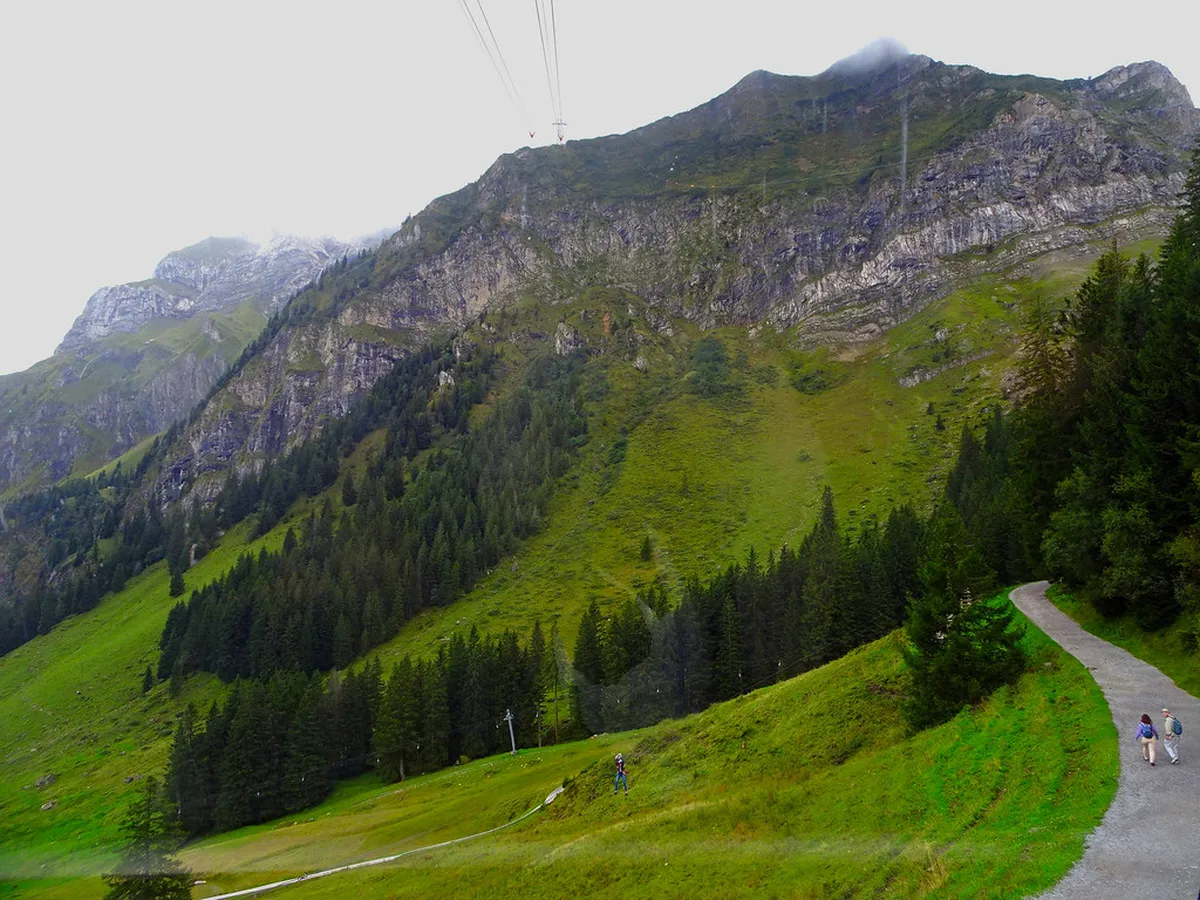
Walking down the mountain is a great way to save money. You can buy a one-way ticket to the top and walk back. The descent from Pilatus Kulm to Fräkmüntegg is very scenic. This path winds through rocky terrain and eventually enters green pastures. It takes about two to three hours for most hikers.
You will find the best summer walking trails on Mt Pilatus on this route. The path is well-marked with yellow hiking signs typical of Switzerland. You might even spot some wild chamois or ibex on the cliffs. Keep your camera ready for these majestic mountain animals. The silence of the mountain is a peaceful escape.
Fräkmüntegg offers many activities if you need a break from walking. You can try the summer toboggan run or the rope park. From here, you can continue walking down to Krienseregg. This section passes through beautiful pine forests and open fields. It is a much softer path than the rocky summit trails.
The total walk from the summit to Kriens takes four to five hours. It is a significant physical challenge for most casual walkers. Ensure you have enough daylight to finish the journey safely. If you get tired, you can board the cable car at any station. This flexibility makes the mountain very accessible for everyone.
Frequently Asked Questions
Are the walking paths on Mt Pilatus free to use?
Yes, all hiking trails on the mountain are free to access. However, you must pay for the transport to reach the summit or middle stations. Prices for the cogwheel railway or cable cars vary by season. Check the latest rates for 2026 before you visit.
Do I need professional hiking boots for Mt Pilatus?
Professional boots are not required for the paved summit paths like the Dragon Path. However, sturdy shoes with good grip are necessary for the Tomlishorn trail. If you plan to walk down the mountain, high-quality hiking boots are strongly recommended for safety.
Can I walk on Mt Pilatus during the winter months?
Many high-altitude trails close during winter due to heavy snow and ice. The Dragon Path usually remains open and safe for visitors. Lower trails near Krienseregg may be accessible for winter walking. Always check the current trail conditions at the Kriens cable car station.
How long does it take to walk the main summit loops?
The smaller loops like the Dragon Path take only 15 to 20 minutes. The Flower Trail requires about 30 minutes of easy walking. If you add the Tomlishorn path, plan for at least 90 minutes total. This allows plenty of time for photos and enjoying the views.
Mt Pilatus is a premier destination for walkers visiting Lucerne in 2026. The mountain offers a perfect mix of easy loops and challenging ridges. You can enjoy world-class views with very little physical effort. Remember to check the weather and wear appropriate footwear for your hike. Plan your next adventure and explore the many Mt Pilatus walking paths today.