Walking from Mt Pilatus Kulm to Tomlishorn: 2026 Guide
Experience the beauty of walking from Mt Pilatus Kulm to Tomlishorn on your next Swiss trip. This trail offers some of the most spectacular views in the Lucerne region. You will stand atop the highest peak of the Pilatus massif in 2026. The path is well-maintained and perfect for most travelers visiting Central Switzerland.
Overview of the Tomlishorn Trail
The Tomlishorn is the highest point on the famous Mount Pilatus. It reaches an elevation of 2,128 meters above sea level. This trail is the most popular of all Mt Pilatus walking paths for visitors. It provides a 360-degree view of the surrounding Swiss Alps and Lake Lucerne.
The path is famously known as the Flower Trail. You will see many rare alpine plants along the rock faces. Information signs help you identify the unique flora during the summer months. It is an educational and scenic experience for nature lovers of all ages.
Most people find this walk very accessible because it is mostly level. The path is carved directly into the side of the mountain. Strong railings protect you from the steep drops on the side. This makes it a safe choice for families with older children.
In 2026, the trail remains a top attraction for those staying in Lucerne. It offers a quick escape into high-altitude nature without requiring expert climbing skills. You can easily complete the round trip in about one hour. This allows plenty of time for other activities on the mountain.
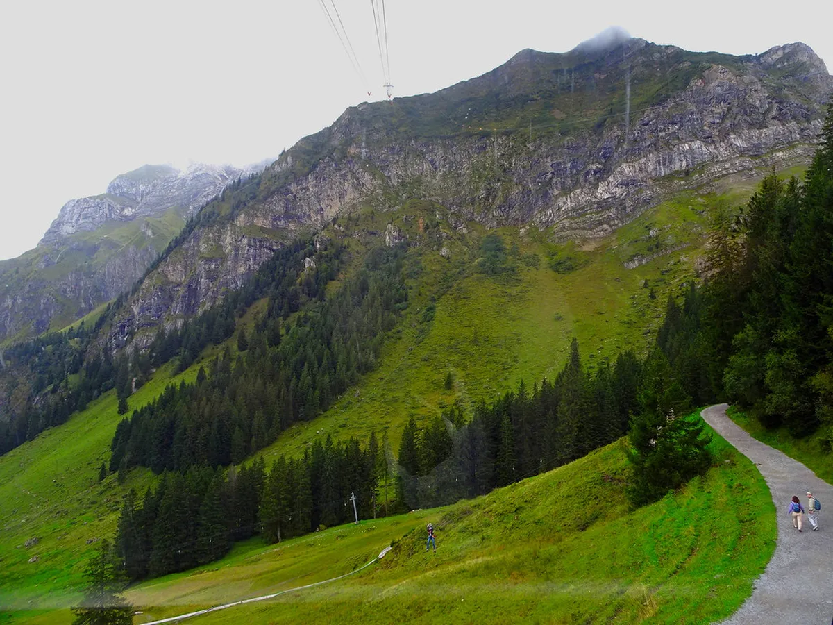
Step-by-Step Itinerary for the Walk
Begin your journey at the Pilatus Kulm mountain station. Follow the signs leading toward the Tomlishorn summit. The path starts behind the Hotel Pilatus-Kulm and the large viewing gallery. You will immediately notice the solid concrete path under your feet.
Walk along the southern slope of the mountain ridge. The trail follows the natural curves of the rock for about 1.5 kilometers. You will pass through several small tunnels carved into the stone. These sections provide cool shade even on very sunny summer days.
As you progress, the views of the Bernese Oberland become clearer. Look for the Eiger, Mönch, and Jungfrau peaks on the horizon. The path narrows slightly as you approach the final ascent to the summit. A short set of stairs leads you to the top viewing platform.
- Start: Pilatus Kulm Station
- Distance: 3 kilometers round trip
- Time: 30-40 minutes each way
- Elevation gain: Approximately 60 meters
Spend some time at the summit to soak in the silence. There are benches available where you can rest and take photos. Once finished, simply follow the same Mt Pilatus flower trail back to the station. The return walk feels different as the perspective of the lake changes.
How to Reach Mt Pilatus Kulm
Getting to the start of the trail is an adventure itself. You can take the world's steepest cogwheel railway from Alpnachstad. This train climbs at a 48 percent gradient through lush forests. The ride takes about 30 minutes and offers incredible engineering sights.
Alternatively, use the aerial cableway and gondolas from Kriens. This route is often called the Dragon Ride. It provides a bird's-eye view of the mountain slopes and local farms. Many visitors choose to go up one way and down the other.
In 2026, a round-trip ticket costs approximately 72 CHF per adult. Discounts are available for those with a Swiss Travel Pass or Half Fare Card. Always check the seasonal timetable before you depart from Lucerne. The last descent usually happens around 5:30 PM in the summer.
The base stations are easily reached by public transport from Lucerne city center. Take bus number 1 to Kriens for the cable car. Take the local train from Lucerne station to Alpnachstad for the cogwheel railway. Both journeys take less than 20 minutes from the city.
Safety and Trail Difficulty Tips
🎯 Insider Tip: Discover the best Lucerne experiences with Viator Tours!
You might wonder how difficult are Mt Pilatus walking paths like the Tomlishorn route. This specific trail is rated as easy to moderate. The surface is paved with concrete or flat stones for the entire length. This prevents slipping on loose gravel or mud during your walk.
Safety is a high priority on this high-altitude path. Sturdy iron railings line the outer edge of the cliffside trail. This provides a sense of security for those who fear heights. However, you should still keep a close watch on children at all times.
Weather at 2,000 meters can change very rapidly. Even if Lucerne is warm, the summit can be chilly and windy. Always check the live webcam at Pilatus Kulm before starting your walk. Do not attempt the trail if there is heavy fog or lightning.
The path is usually open from May through October. During winter, snow and ice make the cliff path too dangerous for hikers. Maintenance crews ensure the path is clear of debris before opening each spring. Always stay on the marked path to protect the fragile alpine environment.
Best Gear and Timing for Your Hike
🌟 Local Expert Tip: Get the most out of your Lucerne visit with guided tours!
Proper footwear is essential even on a paved mountain path. Wear shoes with good grip to handle the occasional steep incline. Light hiking boots or high-quality sneakers are usually sufficient. Avoid wearing flip-flops or high heels for this mountain excursion.
Dress in layers to stay comfortable throughout the day. A windproof jacket is highly recommended for the Tomlishorn summit. The wind can be quite strong once you leave the sheltered station area. Don't forget high-SPF sunscreen as the sun is much stronger at high altitudes.
To avoid the biggest crowds, aim to start your walk before 10:00 AM. The first trains and cable cars arrive early with fewer tourists. You will enjoy a much quieter experience on the trail. Late afternoon is also a beautiful time for golden hour photography.
Bring a refillable water bottle to stay hydrated during your walk. There are no shops or water fountains once you leave the Kulm station. Capture the best photos by looking toward the lake in the morning. This ensures the sun is behind you for the best lighting. Explore more scenic walks in Lucerne 2026 to complete your trip itinerary.
Frequently Asked Questions
Is walking from Mt Pilatus Kulm to Tomlishorn suitable for beginners?
Yes, this walk is very suitable for beginners and casual hikers. The entire path is paved and features safety railings along the cliffs. It is mostly flat with only a few gentle inclines. You do not need special hiking experience to enjoy this stunning trail.
How much does it cost to access the Tomlishorn trail?
The trail itself is free to use once you reach the mountain. However, you must pay for the cogwheel train or cable car to Pilatus Kulm. In 2026, a standard round-trip ticket costs about 72 CHF. Prices are lower if you hold a Swiss Travel Pass.
Can I do the Tomlishorn walk in the winter?
No, the path to Tomlishorn is typically closed during the winter months. Snow and ice make the cliffside trail unsafe for visitors. It usually opens in late May and remains accessible until October. Always check the official Pilatus website for current trail status.
Walking from Mt Pilatus Kulm to Tomlishorn is a highlight of any Lucerne visit. It combines ease of access with breathtaking Alpine scenery. Make sure to pack your camera and a light jacket for the summit. Plan your trip for 2026 to experience the best of the Swiss mountains today.